
15/08/2023 | Using drone imagery and artificial intelligence (AI), scientists from the Leibniz Centre for Tropical Marine Research (ZMT) in Bremen have developed a method that delineates each tree in a forest, along with an estimate of its height and diameter. This capability can help to create biological inventories of forests such as mangroves and also to determine their stocks of stored carbon. Their study recently appeared as a featured article in the journal “Remote Sensing”.
Mangrove forests can store large amounts of CO2 and other climate gases as organic material in their biomass and sediment soils. They are therefore considered one of the ecosystems that deserve special attention in the fight against climate change. Experts estimate that between four and 20 billion tons of organic carbon are stored in these tidal forests worldwide. However, the amount of carbon varies greatly between regions and mangrove stands.
Precise estimates of the carbon stocks in the various mangrove areas of the tropics have hardly existed to date. Usually, measurements of a tree’s height and diameter are taken on site in a few small plots, and based on the wood density and composition of the tree species, the amount of above-ground biomass is estimated. But the nature of mangrove forests makes this task very difficult. Usually they are very remote and difficult to access. You can sink up to your navel in muddy sediment and have to wade or swim through tideways, tormented by swarms of mosquitoes. With all that effort, the estimates are still imprecise due to natural variability.
How can carbon stocks in large areas of remote mangrove forests be more accurately and easily recorded? That was the task facing a team of scientists from the Data Science and Technology group of the Leibniz Centre for Tropical Marine Research (ZMT). "We were looking for new techniques to cover the entire forest area and enable regular monitoring," explains doctoral candidate Daniel Schürholz, lead author of the study. "The more detailed the information about the trees in a forest, the more precise the calculation of stored carbon."
The team investigated the possibility of accurately mapping large mangrove forests with dense canopies. An inventory of individual trees, including their height, location, and canopy area size, allows for more accurate calculation of the amount of carbon stored, as well as monitoring the condition and health of the forest. "Given the current advances in artificial intelligence, we decided to test cutting-edge techniques to automatically detect individual trees in the forest," Schürholz said.
Utría National Park is located on Colombia's Pacific coast. It consists largely of impenetrable mangrove forests. With support of park rangers and researchers from Colombia's Universidad del Valle, and financed by the Colombian Center for Excellence in Marine Science (CEMarin), two of the co-authors of the study, Gustavo Castellanos-Galindo and Juan Carlos Mejía-Rentería, used aerial drones to photograph the forest canopy from above. Back in Bremen, using photogrammetric tools, former ZMT scientist Elisa Casella created large-scale mosaics of the forest that surpassed the detail of satellite imagery. The ZMT researchers then developed an AI workflow that could classify the large mosaics into different habitat categories. For the native mangrove tree species, each tree could be delineated and the height and diameter of its crown estimated. Knowing the species, the height and the diameter of a tree, the above-ground biomass can then be estimated.
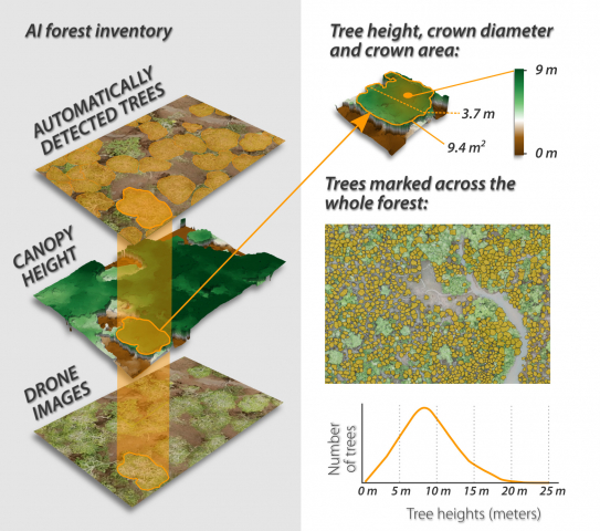
Using artificial intelligence, ZMT researchers automatically marked individual trees in a mangrove forest. Using a tree height model, crown diameter and crown area, a detailed forest inventory was created.
"Using our AI workflow, we calculated, for example, that there are 19,717 trees of the endemic mangrove species Pelliciera rhizophorae in the area studied. This is an estimation that would be very difficult to achieve by conventional means," says Arjun Chennu, an expert in habitat mapping at ZMT and co-author of the study. “The use of low-cost drone imagery with AI tools could be applied to a variety of other features beyond determining blue carbon stocks, such as illegal logging, invasive species detection, or animal and plant community change,” he says.
With their work, the researchers hope to help protect valuable mangrove forests by providing decision makers with more reliable data to argue for conservation or restoration of mangrove forests. "The current hype around cutting-edge AI algorithms should also be applied to environmental issues to improve our understanding of the natural world," Schürholz stipulates. "With the speed of progress in AI, we will be able to reveal more and more details about the processes in nature and better understand how to protect and sustainably manage it."
Similar algorithms could be used to map other ecosystems such as coral reefs or temperate forests, as well as to identify animals and track their movements. Forests in Germany could also benefit from the method. The prerequisite, Schürholz said, is to adapt the AI algorithm to the species found in these forests. "We are providing a good blueprint for a system that can be used around the globe," he adds.
Publication
Schürholz D, Castellanos-Galindo GA, Casella E, Mejía-Rentería JC, Chennu A. Seeing the Forest for the Trees: Mapping Cover and Counting Trees from Aerial Images of a Mangrove Forest Using Artificial Intelligence. Remote Sensing. 2023; 15(13):3334. https://doi.org/10.3390/rs15133334