
16/01/2023 | A new study by PhD student Daniel Schürholz and Dr. Arjun Chennu, scientists at the MPI for Marine Microbiology and the ZMT, explores the possibilities of a new method for describing complex habitats such as coral reefs in detail. Daniel Schürholz`s PhD project is funded by an EU Marie Curie Fellowship. Here is an interview with him.
What was the initial question of the study?
Daniel Schürholz: Correctly mapping and describing the seafloor in coral reefs is a major challenge because these habitats are taxonomically and spatially very complex. We therefore asked ourselves: how can the taxonomic and spatial complexity of benthic habitats in coral reefs be effectively mapped and described?
What was the approach to the study?
Daniel Schürholz: Existing methods have so far yielded limited or partial results in describing coral reef ecosystems. In a previous study (Chennu et al, 2017), we have already shown that a new method we developed, which uses a HyperDiver, could be suitable for a better description of such habitats. The HyperDiver is an underwater measurement device developed by the electronics and mechanics workshop of the MPI.
Our method creates hyperspectral images underwater, offering a wider range of spectral data in a spatial structure. One advantage, among others, is that our hyperspectral camera in the HyperDiver instrument offers over 400 spectral bands, while normal colour cameras have only three bands. Our idea was that the information from the detailed hyperspectral images could be processed by machine learning (ML) algorithms to automatically classify living organisms and substrates of the coral reef floor.
To test this idea, we developed a software workflow that can process larger datasets, describe different benthic communities, use different ML algorithms, and evaluate classified habitat maps from them. This workflow can create detailed habitat maps from hyperspectral images and even analyse the created maps relative to the real community of organisms living on the seafloor.
What are the new findings?
Daniel Schürholz: Through our research, we were able to confirm that accurate mapping of communities on the seafloor in coral reefs is possible. This requires detailed data from our hyperspectral imagery, advanced ML algorithms, and accurate assessments of the results in the correct application context. Our workflow enables mapping of coral reef transects with 87% accuracy with little manual effort and no external data. The maps exhibit fine thematic detail and a spatial resolution of 2.5 cm/pixel. Our assessment of benthic community composition over an area of 1150 sq m in coral reefs off Curaçao showed high consistency.
What can be achieved with this new method?
Daniel Schürholz: The workflow we developed shows a way to create detailed habitat maps of coral reefs. We want to help unite the perspectives of ecologists, environmental managers, remote sensing and ML experts involved in coral reef research.
The thematic and spatial details in our habitat maps will allow ecologists to perform finer analyses of functions and dynamics, patterns and scales in the coral reef. Constant and long-term monitoring will increase our understanding of the complex network within the unique coral reef ecosystem. As a result, our workflow can be effectively used as a survey and monitoring method to devise new approaches and better conservation measures for the preservation of endangered ecosystems.
We hope that it will be possible to use our new method as a standard in in-situ coral reef monitoring once some technological and scientific limitations are overcome, and the cost and performance of underwater spectral survey technology are improved.
Why are the results relevant to society?
Daniel Schürholz: The constant global deterioration of coral reef health threatens the ecosystem services that reefs provide to coastal populations and other ecosystems. Continuous monitoring to protect coral reefs is an essential task to which we at the ZMT and in our Data Science & Technology research group can contribute in line with the goals of the UN Decade of Ocean Sciences.
What are the next plans in terms of results?
Daniel Schürholz: In the next step of this project, we will map all other hyperspectral images from Curaçao with our workflow and generate an integral ecological description from the coral reefs there. We will then compare the data from the analysis with previous studies in the region and try to identify different trends and patterns.
We have also added a multispectral camera (9 spectral bands) and two colour cameras to our underwater instrument, the HyperDiver, to improve underwater spectral survey technologies. Our goal is to describe larger contiguous areas of coral reefs. We have already used these enhancements in a study in Indonesia and have had good initial results. More information will hopefully follow soon.
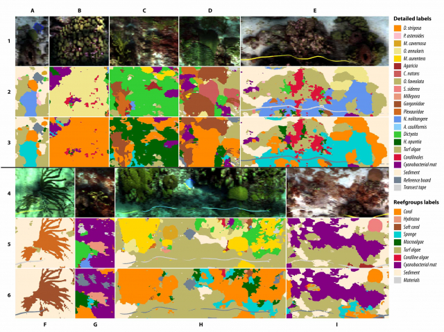
Daniel Schürholz: This figure shows example-sections of our habitat maps that depict the rich structure of a digitized reef community. The maps were produced with our two machine learning methods, with colours corresponding to classes shown in the labelsets-legend (on the right side of the figure). Rows 1 and 4 are the natural view, as would be seen by a human observer. Rows 2 and 5 show the sections in our "detailed" labelset (with coral and sponge described at a species level, for example) and rows 3 and 6 in the "reefgroup" labelset (where labels represent larger encompassing groups, such as "Coral" or "Sponge").
Publication
Daniel Schürholz & Arjun Chennu, Digitizing the coral reef: machine learning of underwater spectral images enables dense taxonomic mapping of benthic habitats, Methods in Ecology and Evolution, 2041-210X, doi:10.1111/2041-210X.14029.